Home Accuracy Summary Days Weeks Worst 500 Last 500 Progress Analysis About
About
Why do this? I like a challenge!
Seriously though, residents of Station Road have said for years that motorists are speeding, with some individuals travelling at extraordinary speeds.
Anecdotes aren't going to convince anyone. What is needed is hard evidence.
This page briefly documents the various technologies available and stages I've gone through to a fully functional, accurate recording system. Hopefully it will help others faced with the same situation.
To save you some time I've now arranged this page from best to worst options.
Some theory first...
The simpler schemes use the 'time of flight' principle:
Two sensors are placed a known distance apart (5 metres for instance), at right angles to the road. A moving object triggers each sensor as it passes by. Using the time difference between the triggering of the sensors it is simple to calculate the speed of the object (as the distance between the sensors is known).
These types of systems are relatively easy to put together with the readily available 'maker' type boards (Arduino, ESP32, Raspberry Pi etc).
Radar
Radar stands for 'RAdio Detection And Ranging', an acronym apparently created in 1940 by the United States Navy.
Radar sends out signals which bounce off objects. Radar is extremely accurate (it is after all what the professionals use!), and easily detects incoming and outgoing objects.
IMHO because of the relative ease of setup, functionality and accuracy radar is the way to go. It just works. After trying all the options (from the bottom of this page to the top) this was the solution.
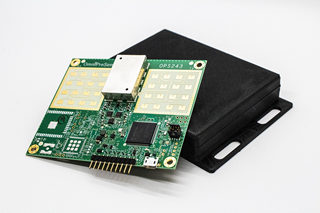
I used a professional grade 24GHz OmniPreSense doppler radar sensor unit, with the correct cosine corrections applied. Power was provided by an old 15V laptop battery (to counter voltage drop - the unit I had accepts voltages from 5 to 24V). Data was processed with an ESP32 and uploaded to the internet. Once running the system was entirely autonomous.
Interestingly the unit has a pin that can fire on certain settable conditions being met. This could (for instance) fire a camera connected to a Raspberry Pi ... I didn't do this though, all speeds were recorded anonymously (there is no record of the actual vehicle).
OmniPreSense have a fully-featured API for their devices with comprehensive documentation, details on accuracy etc. on their website. Recommended.
AI (Artificial Intelligence)

AI has become a buzz-word in the technology world, and is certainly used in plenty of marketing hype. A lot of effort has been put in to 'object recognition' through machine learning, and these technologies are readily available - open source, and totally free of charge. I used YOLO (v8) on a Windows PC, scripting in Python, and it was perfectly possible to accurately detect vehicles (and even categories of vehicles - cars, trucks etc) using a webcam at 90 degrees to the road from an upstairs window. YOLO is a great free, open-source product - it's very straightforward to use.
The difference here is that there is a single sensor (the camera) and it is the movement of the 'bounding box' of the object between subsequent frames that is assessed. For this reason the object must be fully within the frame, so the frame rate must be reasonably high.
Achieving an adequate frame rate was the issue for accurate 'time of flight' calculations with the hardware I was using (i5 processor in the PC and a USB camera). I experimented for a while with a basic NVIDIA Nano but was in danger of disappearing down a seriously deep 'rabbit hole'. The latest Raspberry Pi with a CSI camera would probably work very well with YOLO, and is cost effective. That combination could also be a great basis for 'average speed' cameras.
(I was inspired to try to monitor speeds by this guy. His solution used existing CCTV and the Google Cloud Video Intelligence API, and using the data collected he managed to persuade his local council to install traffic calming measures on his road. His web page is quite technical - but inspirational!).
LiDAR (distance sensor)
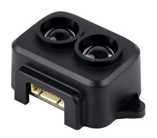
Using 'time of flight' principle. LiDAR stands for 'Light Detection and Ranging' and uses pulsed laser light. As you can see, each unit has transmitting and receiving portions. Better range and reliabilty than ultrasound or infrared.
An issue though with all these two sensor systems though at ground level (and at right angles to the road) is what to do with two vehicles passing in opposite directions at the same time. It would be possible to work out the logic to ignore the far vehicle (as the object distance is returned as the 'trigger') but I couldn't get this to work reliably.
With this and all the below systems you would need to protect the sensors from the elements. I used a short length of drainpipe, with threaded studding sticking out of the bottom to stick in the earth. The sensors were mounted on thin plywood that was a snug horizontal fit in the pipe.
Voltage drop in cables could be an issue. You might have to process your data near to the sensors, transmitting it afterwards, or storing it. You then have issues with power supply (battery or solar may be options), and enclosures etc.
Ultrasound (distance sensor)
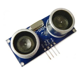
Using 'time of flight' principle. Very simple technology, with transmitting and receiving portions in each sensor but this time using ultrasound. Also very cost effective, the range is far better (2cm to 4m) and I had more success with this. It was more conistent for the near lane, and a bit sporadic for the far lane, possibly nearing the limit of its range.
Infra-red (distance sensor)
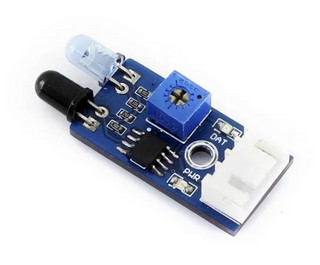
Using 'time of flight' principle. Again very simple technology, with transmitting and receiving LEDs in each sensor. Cheap but not suitable for our purposes because it has a limited range (2cm to 30cm) and is not for use in full sun!